Dec 27, 2010

Anticrepuscular rays - encore

Anticrepuscular rays were recorded already on a photo taken 9 minutes before second contact of the Total Eclipse on July 11, 2010 from the Eclipse City camp on the Balcon de Calafate.

Hardly recognizable on the standard rendering (jpeg below), HDR techniques were employed on the raw-format image. After developing with different exposure values in Silkypix, the resulting three tif-files were combined to a Pseudo-HDR using FDRTools.

The cloud in the upper left-hand corner is obviously the cause for the diagonal dark band extending towards the anti-solar point. The other dark bands could be caused by (unnoticed) clouds overhead.The mountaintop on the horizon opposite to the sun is Cerro Campo 25 de Mayo, el. 1338m, 12.7 km away.


EXIF data for image P1150024:
Panasonic Lumix DMC-FX150
f=7.8mm, 1/125sec, f/3.1 ISO 100


Excursions to Balcon de El Calafate provided exclusively by Mil Outdoor Adventure, regular price US $ 50 w/o solar eclipse.


HDR-Panorama

See the blog entry of July 20, 2010

Oct 8, 2010

Aug 10, 2010

TSE 2010 from Magallanes Region in Chile


Eclipse Total en Torres del Paine Magallanes Chile

5 youtube videos by EsquivelMario
/*views of the umbra from just outside of the totality zone*/

From Puerto Natales
Eclipse Solar, Julio 11 de 2010 by Patagonia Webcam
Video1 on Vimeo /*partial phase*/
Lamentablemente la nubosidad no permitió disfrutar del evento natural en su totalidad. Aqui el registro de Patagonia Webcam.
Video2 on Vimeo /*colorful sky after the eclipse*/
Eclipse y Atardecer en Puerto Natales

Sigue el Eclipse on Chilean IYA2009 website

In the media: La Nacion July 13, 2010 terra.cl July 11

Jul 27, 2010

Refraction at the horizon hugging eclipse


A 
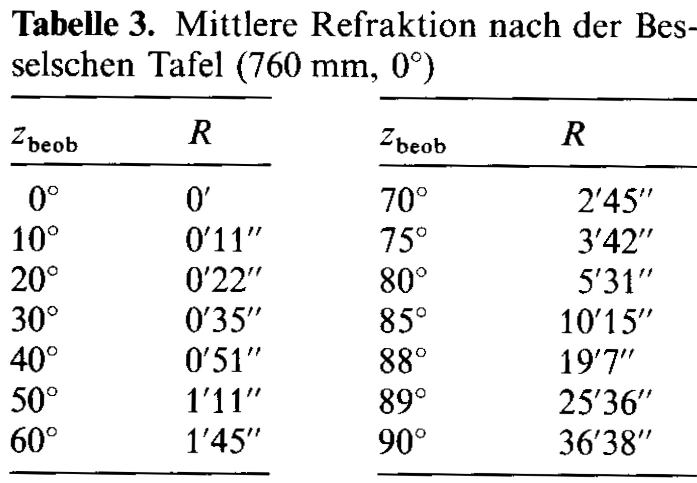
photo taken during totality at 21:50:47 UT was matched with a computed horizon for the Balcon de Calafate observation site. The center of the eclipsed sun is determined to be at an elevation of 1.25 deg, zenit distance z=88.75 deg. This value is by 0.36 deg larger than the elevation uncorrected for refraction and slightly smaller in comparison with the Besselian mean refraction table.


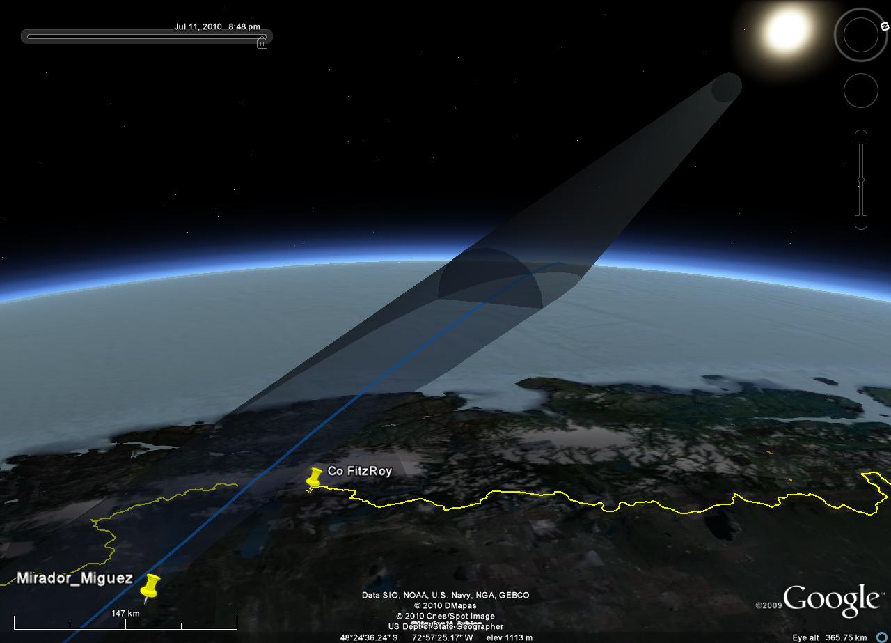
Line of sight towards Cerro Murallon


Details:
Xavier Jubier’s local circumstances tool predicts h=1.0 deg, or better yet with the 5MCSE web tool
Xavier gave the hint: "Worth to mention also is that when you hover the mouse, leave it a
few seconds, over the eclipse altitude, then the value with refraction is displayed. It gives 1.4 degree, but that is with average weather conditions, not the winter ones you had in Patagonia."

The calculator at eclipse-chasers gives a result of h=1.0 deg too for the height of the sun without refraction for mid-eclipse at 21:49:49UT as does Starry Night Backyard .

The USNO online calculator states in 'Notes on the data"
"The altitude is corrected for refraction assuming standard atmospheric conditions.",
the output is again 1.0 deg however, the value without refraction.

The observed refraction angle is somewhat smaller than predicted from the Besselian table
(mean refraction at 0 deg Celsius, 760mm pressure):
z-obs/deg | R
88 | 19’ 07”
89 | 25’36”
90 | 36’ 38”

Glenn Schneider uses this refraction chart as shown in his 1986 eclipse report.
This gives at the altitude of 979 m a correction of 23' for an elevation of 1.0 deg, resp. 24' for an elevation of 0.9 deg.
The time of the picture is between mid-eclipse and third contact, with an uncorrected height of 55.6' = 0.89 deg. This yields an observed refraction angle of 21.6' which is a little smaller than expected from the graph given by Schneider.

A second photo at 21:50:21, closer to mid-totality will be analyzed shortly.


The digital elevation model (DEM) was obtained from Jonathan Ferranti’s site
and is essentially the latest SRTM data ver 2.1 with voids filled. Visualization was done with Microdem
“MICRODEM is a microcomputer mapping program written by Professor Peter Guth of the Oceanography Department, U.S. Naval Academy. It requires a 32 bit version of Windows (NT/2000/XP or 95/98/ME) and is freeware.”

Jul 20, 2010

Anticrepuscular rays during solar eclipse


Pictures taken at 3m 00s and 2m 53 s before second contact in the direction opposite to the sun.
Raw images from Panasonic Lumix DMC-FX 150 were developed with Silkypix DS 3.0, gamma set to 1.0, contrast to 2.5. Autofocus did not work properly, unfortunately.
The vertical "white beam" was readily visible to the unaided eye, I noticed the diagonal feature to the left only upon inspection of the photographs. Or is it in fact a broad dark feature framed by bright rays?
Mystery solved? Comments are welcome. Was it noticed or recorded by any other observers?

Compare this to an image displayed in the gallery at the ESO hotel on Cerro Paranal: dark rays are produced by mountain tops.

The explanation for the eclipse phenomenon as anticrepuscular rays was proposed to me by Mike Simmons (President, Astronomers Without Borders) upon my verbal description. In this context I would explain the bright rays as caused by gaps, i. e. valleys in the distant (below horizon) Andes mountain range. Web links:
http://en.wikipedia.org/wiki/Anticrepuscular_rays
http://www.atoptics.co.uk/atoptics/anti1.htm


-----------------------------
Stefan Krause commented by email on 21. Juli, 2010 02:19
Die Gegendämmerungstrahlen waren mir ebenfalls aufgefallen - allerdings erst nach Sonnenuntergang in der echten Dämmerung.
Der weiße Strahl ist m.E. lediglich ein Kontrastphänomen bzw. der helle Himmelshintergrund zwischen den dunklen Strahlen. Die fast vollständig bedeckte Sonne stellt eine schlitzförmige Lichtquelle dar, welche jeglichen Schatten scharf hervortreten lässt (z.B. http://www.sofi2010.de/bericht/P1170920.JPG ). Dadurch ist der Kontrast zwischen Gegendämmerungsstrahlen und Himmelshintergrund vermutlich größer als dies normalerweise der Fall ist. Die Himmelsaufhellung könnte übrigens durch Aerosole bedingt sein; es gab nach Sonnenuntergang auch ein recht deutliches Purpurlicht. In diesem Zusammenhang mag interessant sein, dass über Südamerika seit Wochen deutlich erhöhte SO2-Werte verzeichnet werden: http://wdc.dlr.de/data_products/SERVICES/GOME2NRT/so2.php . Ich hatte daher bereits vor der Abreise auf farbenprächtigen Dämmerungen spekuliert und bin in der Hinsicht nicht enttäuscht worden. Bereits am Morgen des 11.07.2010 war auf unserer Fahrt zum Perito Moreno kurzzeitig ein schwaches Purpurlicht zu beobachten, gefolgt von heftigem Alpenglühen (s. Bericht).
Viele Grüße aus Bonn! stefan


------------------------
Update Jul 23, 2010: Image processing with FDRTools

method receptor left, compressor right

------------------------
Update Jul 28, 2010: Terrain analysis


A close inspection of the digital elevation model was done with the GIS tool Microdem.
From a point downwards the line-of-sight the look back at the horizon shows indeed a gap at az=308 deg.

More illustrations at the end of album 03

Jul 15, 2010

Total Success in El Calafate


another meaning for TSE 2010, the Sunny Sunday Sunset Eclipse
with Eclipse City on the Balcon de Calafate.
Pictures and videos added July 20 - Album02

image processing, analysis, more pics added July 27: Album03


Unfortunately the second video is out-of-focus, I pressed the button hastily upon third contact

Words cannot describe it adequately, neither pictures. Will post some next week, including two with a riddle, wrapped in a mystery, inside an enigma.:
Shortly before totality a white vertical beam of light was in the sky exactly opposite the sun.
-------------------
addendum July 23:
"Argentina, like Winston Churchill once said of Russia, is “a riddle, wrapped in a mystery, inside an enigma" in Trust, Friendship & Development In Argentina
"The country is hard to understand, harder to explain and impossible to predict."
"...How have Argentina’s recent leaders faired on this scale? Very poorly."
Anybody still wondering why Macair 's LV-BZH did not fly?
-------------------

From an internet cafe in San Pedro de Atacama.

Jun 24, 2010

Goal - moon and airplane


Airplane passing in front of the moon, 2010 Jun 24, 22:03 MESZ
18 minutes after the 1:0 Germany vs. Ghana
Soligor lens f=500mm f/5 and Panasonic Lumix DMC-FX150 camera


Compare to the event on Aug. 30, 2009

Apr 25, 2010

Simulation of the Lunar Umbra on July 11 2010

updated Jun 02, 2010

3D-Visualization of the Total Solar Eclipse on July 11, 2010 in Patagonia at sunset using a Google Sketchup model for the lunar umbra in Google Earth. The umbra is modeled as a glass tube, colored gray on the sunward side from the shadow center and blue in the opposite direction.

Onset of totality at the Mirador Cuesta de Miguez on Ruta 40 near El Calafate.
Ground views are 20 seconds apart.
More images, maps

Video animation - youtube

Astronomy Day


Astronomy Day in Germany, April 24 2010
Astronomietag 2010 Gallery from Stuttgart

Apr 8, 2010

Mercury and Venus Conjunction


Venus and Mercury, Lumix DMC-FX150
2010 April 05, 20h:48m MESZ at left, 21h:03 at right

Mar 8, 2010

ISS Pass


ISS passing over Stuttgart. Computed scene from heavens-above.com at right.
Castor, Pollux, Mars at top right. Regulus between the tree branches.
LUMIX DMC FX150, f=6mm, ISO 200, 30 sec exposure


Raw image processed with Silkypix Developer Studio DS3